Tuesday 11 January 2022

2015 - August - South Downs Way


Much of the south of England is a mystery to me, so the South Downs Way seemed a good way to see if civilisation had penetrated to Sussex.  I got an evening train to Winchester.  I also realised that the next day I was staying in a hostel, which was dry and 2 miles to the nearest pub, and I would have been walking all day in what was forecast to be rain So nipped to Sainbsurys and bought a packet of dried pasta, some salad, and multiple ready-mixed gin and tonics.  Felt smugly prepared, but then found I had left my phone charging cable behind.


Map of the South Downs Way - 100 miles from Winchester to Eastbourne


Day 1. 19 miles.  Winchester to HMS Mercury (abandoned)
  
Up early, queueing outside the O2 shop to buy a cable, and then set off over the bypass which swept traffic through a huge gash in Twyford Down (remember Swampy and the other tree-dwellers?)   Neat, slightly posh countryside, but when I got to the Cheesefoot Head natural amphitheatre I was confronted by a huge metal barrier and watch-posts, like Stalag Luft 11.  But it was the Boomtown Music Festival, and as everyone else was arriving to have fun, I had to divert through a huge muddy field. 

Then, as forecast, it started to really belt down, a serious thunderstorm.  Resisting the temptation to gloat over the happy campers, I put on full wet-weather gear and so was fine, except for some anxiety about being struck by lightning.   I plodded on looking forward to the pub at Exton after 12 miles.  Then I found it was essentially a smart restaurant, so as I peeled off the wet gear and dripped in in my muddy boots, I expected to be immediately thrown out.   But they were charming, a welcome pint in an armchair, pork scratchings and soup. Got settled in and didn't want to leave.


Old Winchester Hill, with beautiful wild-flower planting by National Trust.
It had stopped raining so I forced myself out of my chair got to Old Winchester Hill, and finally struggled up the hill to the Sustainability Centre Hostel.  Then it was back to the hostel routine perfected  on the Camino – into the shower with mucky clothes and wash them and myself at same time, and then collapse onto the bed.  Blessed my foresight in booking a double room to myself, and stocking up on G&Ts.


This is supposed to be a wonderful view
Day 2 17 miles. HMS Mercury to Cocking


Woke to find thick mist. Briefly had a fine view of the A3, but then the mist closed in again. Looked forward to breakfast in the cafe in the Queen Elizabeth Countty Park, but it didn't open for another hour.  So headed into the forest, and got lost.  Spirits dropped.  The guide said ‘great views’, but couldn't see a sausage.


Beacon Hill: 'fine views' are claimed
Listened to Desert Island Discs which raised the mood, but even better spirit-raising when I got to the pub at Cocking by 2.30 and they were open and serving food.  Into a rather smart B&B, and laid waste to the bathroom as usual.  But it was all neat and tidy by the next morning. 

I then found I could not charge my phone even with my new cable, so I had no music, compass, email, watch or camera. Or phone.  Tried to convince myself this was a good thing, as am really too reliant on these things.


Day 3 19 miles, Cocking to Washington


Relieved to find good weather, large breakfast and set off singing and clicking my stick on the ground in an irritatingly cheerful manner.  Beautiful day, and the path turned into a classic Way – on a ridge with great views to the sea on the south and the wooded Sussex weald on the north.  Fine drop almost to sea-level at Amberley – again a welcome pub before slogging back up to the standard 200 metre height.  I knew I had to get a bus at the A24 in Washington, and arrived just to see one go.  Sat by side of road, with no idea what time it was, but enjoying watching cars go past.  Rather sorry that another bus came along within 10 minutes, but went into Worthing.  Worthing has not got a great reputation - someone told me once that they saw a notice in a train toilet saying "Do not flush while in a station", and someone had added underneath "except Worthing".  But I had a fine B&B with a sea-view, and found some excellent food.  And used a public phone box for the first time in years. 


Day 4.  14 miles. Washington to Pyecombe
 

Amazingly, got bus and met Steve as arranged at Washington.  Very good to have someone to walk with after 3 days solitary, and we chattered along up to Chanctonbury Ring, which sounds faintly obscene, but is reputed to be seriously haunted.  Some campers had stayed there.

Day 5.  XX miles. Pyecombe to Rodmell


Day 6.  XX miles. Rodmell to Eastbourne


Thursday 3 December 2015

2015 - November - Trek to Annapurna Base Camp

The view from our first 'guest house' in Ghandrouk

The trek to Annapurna Base Camp is popular but quite tough. We hadn't intended to do it but got a bit carried away, so rented some extra boots, poles, jackets and so on, and set off. 

Our first stop was Ghandrouk, which is a sizeable Gorung village - one of the communities the Gurkha soldiers come from - our guest house had proud photographs of local men in enormous British Army  shorts.  Since Joanna Lumley successfully obtained rights for ex-Gurkhas to move to Britain, some of the properties have been abandoned.  The road stops a few miles before Ghandrouk, and after that everything has to carried up on the backs of mules or people.

The view from Chomroung at lunch on day 2 - we've
got to get across to the spot half-way up the right-hand side of
the opposite hill for our guest-house


The good news is that the trek just involves following a river for 2 miles – the bad news is that the 2 miles is vertical, from 1100 metres to 4100 metres. So it’s 4 days of slog upwards, quite a lot of it on steps.

Even this would not be so bad if the path just kept on going upwards, but there are huge valleys to cross - after Chomroung we were staying on the hill opposite, but first had to plunge down to cross a river on a spindley bridge.  The valley was more than 300 metres deep, like climbing down and up the Eifel tower.  After two of these in a day, it all gets a bit wearing. 

I was grateful for my twin poles to protect my knees, but tough Kate just scorned such artificial support.


End of Day 3 - distant view of Deurali where we spent the night.  Kate holding my poles.


We stayed in 'guest houses', which are situated about 2 hours apart. Basic rooms with a couple of beds for about £2 a night, but relatively expensive food - which is hardly surprising as everything has to be carried up on the backs of porters.  Deurali even had a huge Italian expresso machine, which sadly was not working.


The usual wonderful spelling - anyone for an Apple Fitter or a Roasty?  But everything from Tuborg beer to Pringles was available, at a price.  The menus were basically a choice between spaghetti, noodles, macaroni or chow mein - all very filling and all remarkably similar.

There was usually wifi, and even hot showers, or at least a bucket of hot water.  But it was cold at night, and we asked for extra blankets (well I did, being the feebler member of the party). 
End of Day 4 - reaching Annapurna Base Camp at 4100 metres with Padam and Ramesh.
Being old and having money, we supported the local economy by having both a guide and a porter, which was probably unnecessary but meant we carried almost nothing, and this makes a difference when going up and down miles of steep stone steps.  Our guide, Padam, was wonderful and patient, while Ramesh our porter just kept on smiling and enjoying the trip, taking more pictures than we did. 


The view from above Annapurna Base Camp - prayer flags next to the glacier, and guest houses with a great view. 
The area around Annapurna Base Camp (or ABC as it is known) is also known as Annapurna Sanctuary - surrounded by peaks up to 8000 metres, confusingly called Annapurna 1, Annapurna 2 etc.  Tough if you climbed the wrong one.  The whole area is dotted with memorials to people who have died there - the area is very popular with Koreans, and three of their top climbers disappeared on Annapurna 1 in 2011.

At 4100 metres, the base camp is just half-way to the top of Annapurna, but we felt no inclination at all to go further.

The altitude was not too bad as we had taken 4 days to get there - a slight headache and thirst.  Wonderful sunset, moonrise and sunrise.


Panorama from Base Camp -


With some relief, walking down the valley on Day 5.
We were so lucky with the weather - fine days and not too hot.  It could have rained or snowed, and we had all the kit, which we fortunately did not have to carry and so could just  focus on putting one foot in front of the other.

Hot springs at Jinhu at the end of Day 6 - easy to throw ourselves in the icy river

We just plodded on, for about 6 hours a day, stopping at guest houses for morning tea and lunch.  All very civilised, and a bit like doing the South West Coast Path, but without the cream teas, and with some tough ups and downs.

Padam leads us out at the end of Day 7
The earthquakes, and the current problems with fuel and cooking gas, mean that tourists have been advised to avoid Nepal and the country is suffering even more because of this. There was even a strike organised by the Maoists on the day we walked out, and we had trouble getting a tourist bus to take us back to Pokhara.  

But we have to admit that all this disturbance was to our advantage - this is generally a very busy route, with crowded guest houses and droves of trekkers, but we saw relatively few people and had the pick of the rooms.  And, as usual in Nepal, everyone was helpful and kind.  A great trip.

And if you need a great guide in Nepal, please contact Padam Raj Adhikari on gpadhikari92@yahoo.com .


Saturday 7 November 2015

2015 - November - Ceremony at Bouddranath

Bouddha, Kathmandu, Nepal

The first morning here we went down to the damaged Stupa, sad to see the state it was in, with all the brick structure on top of dome demolished. But we also found huge crowds, mobs of monks, and a row of high lamas on thrones of varying highness.

Clearly something big about to happen.  We had no idea what, but jostled among the river of people, and found a 'band' waiting for things to start.

Ladies were passing round butter tea from huge kettles - an acquired taste.


The big hats were out, and the horns ready, but we still did not know what was going on.


Then we realised that the monks on the back of a truck were collecting offerings from the crowd, stuffing the katas (traditional silk scarves) into a hollow container, and separating out the money.  We quickly bought a kata, Kate shoved her way to the front in good Tibetan style, threw it to them, and in it went. 

We finally realised that this was all going to go into the stupa before it was restored, and felt so lucky to be able to participate.


Just as well we moved quickly, as suddenly the musicians started up.  The boy on the left had the job of carrying the front of the trumpets, and didn't seem too pleased about it.  No ear-protection provided.


More monks piled onto the truck, clearly having a great time as the procession pushed through the crowd, preceded by the musicians making a wonderful noise.  They all went right round the stupa, and then a crane lifted the pillar onto the platform below the dome.

The issue was, how were they going to get it up to the top?  We got a ringside seat in a cafe, and, along with everyone else, settled down to see if it would all end in disaster.


The organisation was excellent, although a health-and-safety nightmare. Muscular young monks clambered over the rubble, tying the pillar to a chain that was strung between the crane and the top, where a cheerful gang stood and hauled it up.  

Fortunately it was not too heavy, and so nobody was pulled off the top, and it slid up the dome rather rapidly - it should have been slower for the full dramatic effect.  But it arrived at the top to huge applause, from both the crowd and a huge variety of monks and nuns, including the beautiful pink robes from Burma. 

And there it is now, sticking up in the air, waiting for the new brick pyramid to be rebuilt around it. And our little offering will be inside.

Monday 26 October 2015

2015 October - Through the Kangra Valley


We went down into the Kangra Valley which runs below Dharamsala to stay on the Darang Tea Estate.  This turned out to be a real 'homestay' - living in a room in the bungalow, eating with the family (lots of their fruit and veg), and shouting at rather deaf but still very bright 93-year-old granny.  Even a chota peg before dinner. 


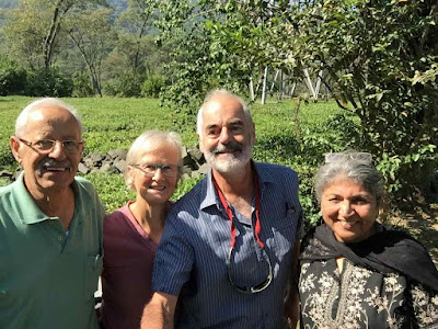
Here we are with Naveen and Neera, with the tea plantation behind.  This is using my selfie stick, which is taking all my concentration.
We went off to the Sherabling Tibetan monastery which was very fancy - in fact 'bling' is the right term.  The Dalai Lama's temple in Macleod Ganj is very modest indeed, but this was the full business - big campus in a forest, huge buildings, and the main temple and courtyard that had all been roofed in.   Got to see some great practice - huge drums, trumpets, and a massive gong to get the monks back from their break.
                      Then, rather bizarrely, we headed off the the landing site of the World Para-gliding championships which were due to start the next day at Bir, just down the road.  All very beautiful and Himalayan, with a sky full of practicing paragliders, although the landing site was rather Indian, with stray dogs, chai stalls etc. And, in spite of its name, Bir was a dry town and so I am not sure how all those para-gliders felt about not getting a drink at the end of the day.


The next day came the major treat - a ride on the Kangra Valley Railway, a 100-mile narrow gauge built by the British in 1929, and still going strong.  Worked out the time-table and fares, which was 10 rupees each (10p).  


The average speed of the train was less than 20 mph, and it was clean and cool inside.  But clearly the thing to do was to sit on the step as we trundled along. Which I did.  Some of the landscape was spectacular - rattling along looking down gorges in the sunshine.


Finally, if the video works, it shows us going over the curved viaduct just before Jwalamukhi Road - such excitement!


Sunday 25 October 2015

2015 October - Up the local mountain from Macleod Ganj


This is the view looking up from Triund, which at 3000m is 1000m above Macleod Ganj - that 1000m is a few-hours slog up a good path.  Triund is a 'base-camp' for further exploration, with tents and rooms to rent, and inevitable chai-tents. We had booked a guide to take us up towards the Andrahar Pass at 4300m - but we were not going to attempt that.

Here is the memsahib in the morning at the lodge we had booked through Summit Adventures - fairly rudimentary  but a bed and a warm sleeping bag, which was needed.  Had a snooze in the afternoon and woke to have pakora and chai in bed, which was a bit of a treat.  

The earth toilet in a small tent reminded us of trekking, similarly the joy of 'tent-tea' in the morning.  But happy not to be sleeping in a tent.                                     


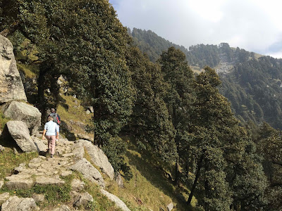
The path leads steeply up from Triund along a steep cliff through fine forest which eventually peter out into a slightly desolate landscape of large granite rocks interspersed with grass, rather like the Dolomites. 


The mist started thickening, but then down towards us came a huge herd of goats which had been led over the pass that morning. They were, not surprisingly, exhausted as they had been on the move since 5am in incredibly inhospitable terrain.  The shepherd was carrying the youngest goat, and we both had a cuddle.  Then it just sat looking a bit pathetic with a 'carry-me' expression, until it got picked up again.


We got to the glacier, which was  grubby and slippery.  Then on up an almost vertical path to the Lahesh cave at 3500m, and that was quite far enough.  Very happy to turn back - the weather was grim and I did not envy the people we saw carrying on.


Met the goats again on the way down, who had collapsed in heaps where the grass started, and were due to stay there and recover.  We just stepped through them, like that scene at the end of The Birds.

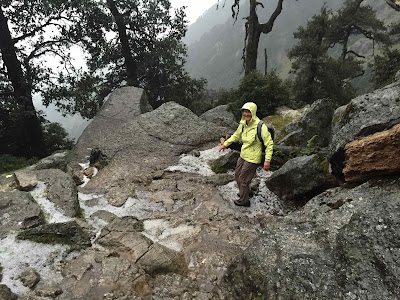
 The next day we started down happily the path from Triund, when there was the most dramatic storm  - huge lightning flashes, deafening thunder and hailstones like large ballbearings.  Almost frightening. We plodded on, Kate helpfully pointing out that it all was transient, but we got very wet and cold, not being properly eqipped for storm and tempest. Briefly stopped at a chai-stall only to find a group sheltering who were on a charity trek for Alder Hey hospital.

We were very relieved to be greeted by a blast of hot air as we walked down to Dharamkot, and looked forward to a latte and pancake, just like Ice Cold in Alex.  But the first cafes we came to had no power, so no latte  - this never happened to John Mills and his Carlsberg. But eventually found someone who could provide the goodies.

Friday 2 October 2015

2015 - September - raining in Amritsar


 September 2015 Amritsar


My selfie-stick had come apart, and so we got directed to a warren of little shops that did everything electronic. They managed to re-solder it, and then mend my Mac charger, and sell us a 4-pin plug converter, all for 170 Rupees (£1.70), and refused to take more.  The picture is an unposed test of the stick.

But then the rain came down - real monsoon style, and the streets filled up.  


Traffic was a shambles, and in the end our auto-rickshaw driver just gave up, and passed us over to a cycle-rickshaw. 


We had been reluctant to take the cycle-rickshaws as they seemed to much like something out of the Raj, but they were the only practical way to get through the streets.   

 
We were fine, but people were stuck pushing their conked-out motorbikes through a foot of water.  The streets were full of potholes which became invisible, and even open drains - locals put little red flags up as warnings.  I thought immediately of classic Laurel and Hardy scenes of walking through a puddle and disappearing, but it isn't so funny in real life - apparently people regularly just drop into the sewers as they are walking along.

In the evening we set out to eat at the 'Brothers Dhaba' - an Amritsar institution (a dhaba is midway between a cafe and restaurant, like a snack-bar, and Punjabi dhabas are famous - we saw them all over Kashmir and Dharamsala).  We had to take a cycle-rickshaw through the pitch-black flooded streets, it would have been lethal to try and walk.  And outside the Brothers Dhaba they even had a makeshift jetty so that customers could get in without wading.  We sat inside by the window, watching people struggle to get home.  Apparently these floods are a regular occurrence, the drains having been blocked by shabby road mending.

We were quite generous to the rickshaw-wallah, and after a good dinner we came out to find that he had waited the whole time to take us back to the hotel.  So we stepped daintily along the jetty and got home quite dry, feeling like the Sahib and Memsahib.